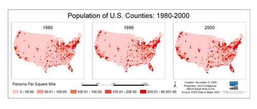
Geographic Information Systems (GIS) Mapping
Whether combined with other research techniques or standing alone, GIS are powerful tools for policy analysis. Optimal’s GIS staff is trained to perform specialized GIS analysis and to provide cartographic services for clients in both the public and private sectors. Our staff has a wide range of capabilities, including:
- Data Collection
- Data Entry
- Asset Management
- Geocoding Services
- Topological Data Cleaning
- Demographic Analysis
- Thematic Mapping
- 3-D Mapping and Fly-Through Animations
- Spatial Analysis
- Suitability Analysis/Site Selection
- Network Analysis
- Location Analysis
- Crime Analysis
- Market Analysis
- Cartographic/Layout Services
Optimal’s staff utilize ESRI’s ArcGIS Desktop (www.esri.com) in-house, but are familiar with numerous other GIS and Cartography packages. Staff competency and fluency with the latest software upgrades/developments and emerging-analyses techniques is reinforced through on-line training, attendance at relevant conferences, and the latest product manuals and texts.
For more information, please contact us at info@optimalsolutionsgroup.com.
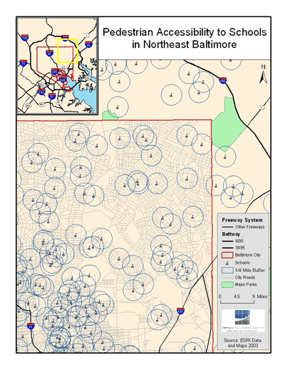
Optimal researchers demonstrate the large segments of the City that are not within a ¼ mile walking distance to schools. Data for this map was obtained from the ESRI Data and Maps 2003 Dataset


Connect with us Facebook
  Twitter
  LinkedIn